Professional Blogs:
Based on my research of the links provided to other blogs, it is clear that individual blogs varry based on topic, purpose of blogging, and the bloger themself. This may seem rather obvious but by comparing blogs side by side the different elemnets to each blog become quite clear.
For example, the "professional" blogs such as those on the ESRI website are often verry informational. Many of them were written as a reporter would on a given story. Blogs about technology and software usually gave the 411 on the plus's, minus's, and attributes to them, as well comparisons to older models.
Other "professional" blogs were somewhat more casual and they conveyed the writers personal opinions on a given GIS based topic, or hints on using software treat they had played around with. Yet whatever the topic was on the ESRI blogs, they all had some common themes such as higly organized thoughts and in depth information. Additionally they all ultimatley were designed to help the veiwer in some way shape or form on the given topic. Purpose and direction in these blogs were easy to identify.
Student Blogs:
The "student" based blogs differed from the "professional" blogs and also had several similar qualities. Since the student blogs are all of college level quality, they were usually well written, coherent, and had screenshots that helped to visually connect the topic being discussed just as the professionals had done. The main differnce between the two was the purpose of the blog. Since the professional blogs often had more information to convey, they were slightly more organized since they had to be for the reader to easilly view all the information. However in my opinion, the most obvious differnce was the collective organization of all of the blogs. The more professional bloggers had their blogs organized by topic rather than by the author. This appeared to be a direct result of all of their blogs being informational based. Whereas the student bloggers had their blogs organized by auther, which then forced the reader to sift through each individual's blogs for the a given topic. The simple fact that these blogs were completed for a grade with a focus on being comfortable with blogging and learning about relevant mapping topics drove the student blogs to be the way they are.
Conclusion:
The student blogs and the professional blogs were quite similar and only differed due to the purpose for the blog. Had the purposes been the same they may have been more similar. From Researching this I personally have determined that one of the major aspects that my blogs lack are the visuals accompanying them.
Wednesday, April 21, 2010
Wednesday, April 14, 2010
Maps And Games
Map Games:
There are several map games on line, most of them are geared toward the grade school age bracket. All of the ones that I found were trying to teach the target students something, usually geography. These educational map games varied in complexity depending on the age bracket for the target students. Some were quite simple and were focused around simply understanding map basics such as symbology. One map game in particular had a quirky guide that helped the child playing the game to identify symbols on a map and what they represented. These appeared to be targeting a younger crowd, while other games were designed for a highschool understanding level. The games for older students often were designed to teach the students capitals of states and countries, something that only older children would be able to learn and have the patience to try to understand the given material.
Some of the games that I found seemed to have little to no educational value, they were simply games. An example of this was a puzzle map game that was essentially a digital map puzzle where the peices were jumbled up and the player needed to fit all the peices back together. This game simply used a maping theme to entertain the player while trying to get all the epices back together.
Games Using Maps:
Unfoutunatley there were not a lot of examples online of games that used maps or mapping in the process of playing. I was however lucky enough to partake in such a game last semester. The game was called geospatial disc golf. Each group went out and created a disc golf course hole that encorporated structures and obstacles present on campus. We then created maps using GIS that were to scale with the real life golf course. The purpose of the execise was to learn the techniques used in creating digital maps that could be created and edited in GIS. It also taught us the practicality of doing so, in this case it allowed us to create a digital "booklet" of every hole on our class golf course. The actual gaming aspect of the project was when we were able to play the holes that other groups made and then challenge that group to play our course as well.
Tuesday, March 2, 2010
Mapping history in Mass
I thought it was pretty cool to look through some of the websites that were posted that had old maps of Mass. One in particular that was pretty cool was one I found of Westfield that dated back to the 1800s. It was neat to see a map of the buildings and all that that wasn't just a topo map. it had all the buildings, the church, and people depicted waking through what today is the center of Westfield. Additionally Some of the streets that were present then are still around today.
It might be interesting to create a map that compares Westfield back in the 1800s to how Westfield today. Another idea might be to try to look at wetlands in the area in general from past to present. This way we if there's any loss of wetlands we might be able to map the loss which might be useful in conserving them. Or possibly now that we've looked through a few historic maps it might prove useful to try to find historic buildings or identify historic areas so that a map could be created to help the conservation and preservation of such areas and landmarks.
Finally i found some of the very old maps of Boston to be insightful on the earliest development of the city, and how the city has expanded and the land itself has changed do to dredge work. This might also be a topic to map where we could map the changed land mass or map the development of boston over several time intervals.
Wednesday, February 3, 2010
Social Explorer Review
I thought this website was well put together and very informative. It was easy to glance at the population map for a given time period and easily tell the population density for the area. I also thought the slide show tool was pretty cool because it allowed the user to essentially take snapshots of a map and easily compare them side by side. I also liked how you could compare large or small regions with the zoom tool. It was quite easy to find my home town and create a slide show of the pop density over several years and compare and contrast them.
Aside from the easy use of the map, I believe that from an amateur map makers stand point it is a well constructed map scheme. Personally i found the pop density shown as different shades of a single color to be much more helpful than several different colors all in one map. Also I think that brown is a good color to do this with because it is easy to distinguish multiple shades.
I also like the setup of the legend because it doesn't use the traditional style of putting its tittle at the top. The reason I like this is because the user can still tell what the map is about because the tittle is the first thing that the user looks at because of its size, and then I can organize what information Id like to see before seeing the results of the current map.
Wednesday, January 27, 2010
Mapping Music
After typing "maps of music," I found very few maps that seemed pertinent to this assignment. However after looking around for a bit I found this map, Islands of Music, that could be applied to this assignment. Unlike traditional maps it doesn't display any true geographic information. Instead it depicts several genres of music as islands in an ocean. The islands that are in close proximity to or attached to one another are more closely related than those that are farther away from each other. For example, two of the most different types of music, "chill-out" and heavy metal, are situated in opposite corners on the map. Similarly, indie-pop and emo are also in different corners.
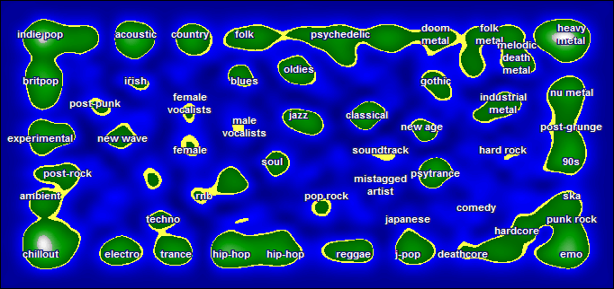
Personally I agree with maybe half of this map. Folk metal, melodic death metal, industrial metal, and nu-metal are all clearly related to heavy metal. But Are all these types of music truly derivatives of heavy metal, or psychedelic or hard rock which came first? One of the islands that I agree most with is the one just under heavy metal. The 90's music definitely lead to post grunge which developed into nu-metal which is mostly attributed to the 2000's. The bottom right island is only half right however. Deathcore and hardcore are definitely related to emo but in no way did emo come first. Also ska and punk rock are pretty close and possibly show a few similarities to emo but are so distant they really should be different islands. A few of the other islands that I agree with are country, folk, oldies, blues, and jazz being related to one another.
Most of the parts of the map that I disagree with are on the left side. For example, techno, electro, and trance have no business being anywhere close to "chill-out." And why aren't acustic, reggae, and psychedelic all close to "chill-out?" Additionally didn't indie pop develop from brit pop and not the other way around? Also I personally feel that ambient and post rock are so "far out" that they really should just be little islands in the middle of no where. Finally, one of the islands that bothers me the most is how in the world is psychedelic anywhere close to related to whatever doom metal is.
In conclusion I feel that this map is based on a really neat concept, it just needs to be revised.
Subscribe to:
Comments (Atom)